Introduction
Last year, during an integration project for a compact EO/IR gimbal destined for a medium-altitude UAV, we ran into a recurring issue: the onboard thermal imager could clearly detect vehicles from several kilometers away, but the operator couldn't reliably tell whether a target was 1.2 km or 2.5 km out. The camera delivered excellent imagery—but it couldn't answer the one question that mattered most for the mission: where is it?
That experience reinforced what we already knew from years of work in ISR payloads: detection and localization are two entirely different problems. Imaging sensors give you line-of-sight. They do not give you distance. Without distance, a target remains a point in a 2D frame, not a georeferenced position actionable for surveillance, targeting, or situational awareness.
This article shares what we've learned about closing that gap—specifically, why laser rangefinders have become non-negotiable in modern EO/IR systems, how they complete the localization chain, and what engineering trade-offs matter when integrating them into compact ISR platforms. We focus on their role in the full ISTAR target acquisition cycle—from initial detection to precise geolocation.
The Core Problem: Line-of-Sight Is Not a Position
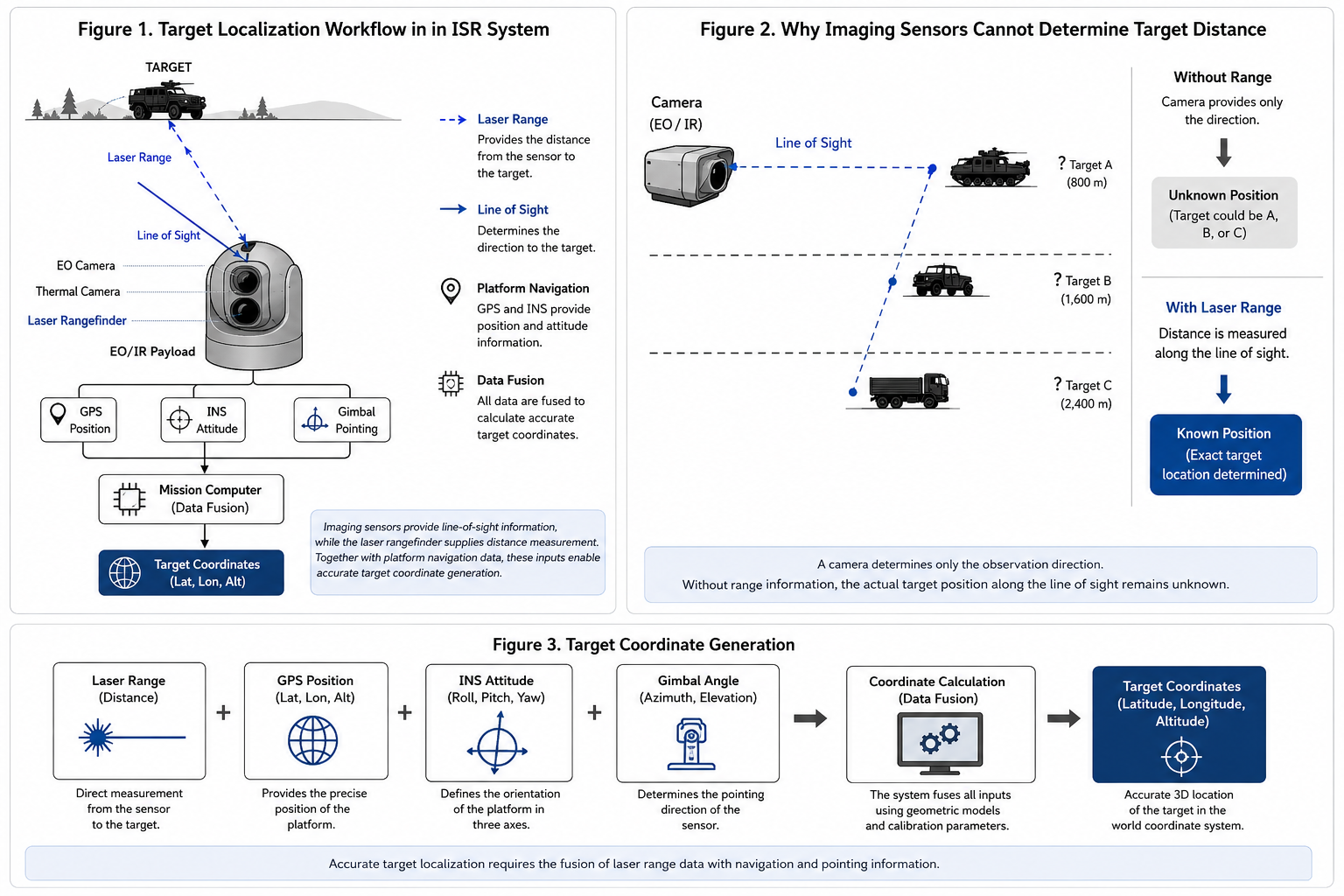
A high-resolution EO camera or thermal imager captures light reflected from a scene. Each pixel corresponds to a direction, but not to a physical distance. From an engineering standpoint, the camera provides line-of-sight—the vector from the sensor toward the object. It does not tell you how far along that vector the object sits.
Consider a UAV observing a moving vehicle. The camera can track it, classify it, and even estimate its speed across the image plane. But the vehicle could be 800 meters away or 2.5 kilometers away—both scenarios can look visually identical depending on zoom and field-of-view settings. Without range, the localization equation is underdetermined.
Accurate geolocation requires four data sets:
- Platform position – from GNSS/GPS
- Platform attitude – roll, pitch, yaw from an INS
- Line-of-sight direction – gimbal pointing angles
- Target range – direct distance from platform to target
The first three define a direction vector. The fourth fixes the target's position along it. Miss the fourth, and the coordinate calculation remains incomplete.
Camera resolution improvements do not solve this. Higher pixel counts deliver more detail, but they deliver zero depth information. That is why EO/IR payloads increasingly pair imagers with laser rangefinders—not as a replacement, but as a complementary measurement channel. For ISTAR applications, this combination is what transforms raw sensor data into actionable target acquisition.
How Laser Ranging Completes the Picture
Most modern long-range laser rangefinders operate on the time-of-flight (TOF) principle: a short pulse is emitted toward the target, reflected, and detected by a receiver. By measuring the round-trip time with high precision, the system calculates distance—typically to meter-level or sub-meter accuracy.
This direct ranging capability is what distinguishes pure surveillance from true ISTAR target acquisition—the latter requiring not just detection, but precise geographic coordinates.
Once range is available, the localization chain becomes straightforward:
Platform GNSS + INS attitude + gimbal LOS + laser range = target coordinates
The mission computer integrates these inputs to generate a 3D geographic position. Instead of simply knowing where the target appears in an image, the system knows where it exists in the real world.
This capability supports continuous tracking, georeferenced surveillance, mapping, and multi-sensor data fusion. During extended missions, repeated range updates allow the system to maintain positional accuracy even as both the platform and the target move.
Unlike stereo vision or monocular depth estimation—which rely on assumptions and computational inference—laser ranging provides a direct physical measurement, reducing uncertainty and improving reliability.
Why 1535 nm Has Become the Standard
.jpg?w=823&h=823)
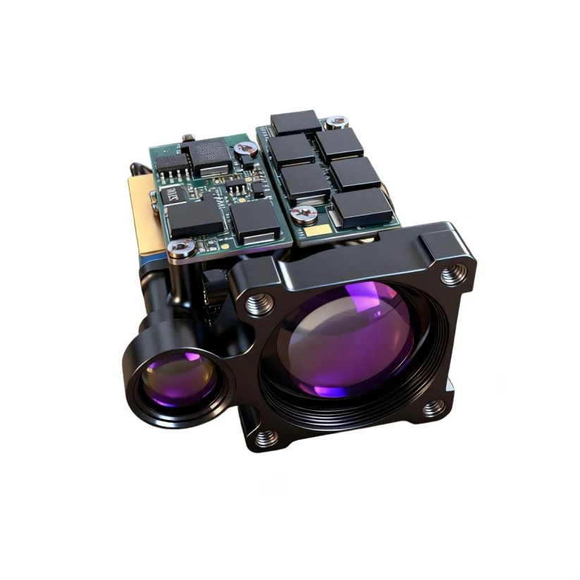
Among available wavelengths, 1535 nm has emerged as the preferred choice for compact ISR payloads, particularly where long range and eye safety are both priorities.
Compared to 905 nm systems—common in short-range industrial sensing—1535 nm offers two distinct advantages:
- Better eye safety margin: allows higher pulse energy within safe exposure limits
- Superior atmospheric transmission: reduced scattering, particularly in haze or light fog
These characteristics make 1535 nm particularly suitable for airborne, ground-based, and maritime ISR platforms, where operations often occur in environments shared with personnel or other assets.
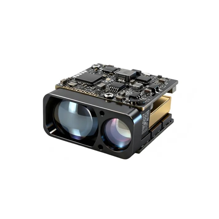
Beyond wavelength, the module-level requirements have become equally important. System designers now expect compact rangefinder modules that are:
- Lightweight and low-power for UAV integration
- Mechanically robust against vibration and shock
- Easy to align with EO cameras and thermal imagers
- Compatible with standard communication interfaces (RS422, UART, TTL)
The trend is clear: the laser rangefinder is not an accessory—it is a core sensing component integrated into the payload architecture from day one.
Engineering Factors That Affect Real-World Accuracy
Spec sheets tell only part of the story. In practice, target localization accuracy depends on the entire sensing chain, not the rangefinder alone.
Atmospheric Transmission
Fog, rain, dust, and haze scatter or absorb laser energy, reducing the signal-to-noise ratio at the receiver. Thermal turbulence over roads or water can also introduce beam wander, particularly during long-range daytime observations. Maximum operational range is therefore always application-dependent—standardized NATO target specs provide a baseline, but actual performance varies with real-world conditions.
Target Reflectivity and Size
Not every target reflects equally. Road signs and metallic surfaces return strong signals; vegetation, painted vehicles, and camouflage materials return weaker ones. Target size also matters—a building is far easier to range than a person or a small UAV. Manufacturers often specify performance using standard reflectivity targets (e.g., 30% or 80% reflectivity), but field performance depends on the actual observed object.
Beam Divergence
A narrower beam concentrates more energy on the target, improving long-range capability. However, low divergence requires precise optical alignment, and at extreme ranges the laser spot may exceed the target size, causing returns from surrounding objects to contaminate the measurement. Selecting the right divergence involves balancing range performance, target size, pointing accuracy, and optical complexity.
Platform Stability and Pointing Accuracy
The laser measures distance only along its pointing axis. Any vibration, structural flex, or gimbal error directly affects what is being measured. For mobile platforms—UAVs, ground vehicles, maritime vessels—stabilized gimbals are essential. Even so, residual pointing error remains a dominant contributor to overall localization uncertainty, especially at long range.
Navigation Accuracy
Accurate ranging does not guarantee accurate coordinates. The final geolocation also depends on GNSS position and INS attitude. Small attitude errors—fractions of a degree—can translate into tens of meters of ground error at several kilometers' range. For high-precision applications, the rangefinder, INS, GNSS, and gimbal must be treated as an integrated positioning system, not independent subsystems.
Sensor Alignment and Calibration
The optical axes of the visible camera, thermal imager, and laser must be co-aligned. Calibration compensates for mechanical tolerances and ensures that the laser measures the same point displayed at the center of the image. Even minor misalignment introduces noticeable offsets at long range—making optical calibration a critical step in system integration and maintenance.
The Role of Laser Rangefinders in the Target Acquisition Chain
Target acquisition in ISTAR systems is a multi-stage process: detection, recognition, identification, and localization. Imaging sensors handle the first three. The fourth—localization—requires range. Without laser ranging, the acquisition loop remains open: the operator sees a target but cannot act on its position.
By providing accurate distance at the moment of detection, laser rangefinders close this loop. They enable immediate georeferencing, which in turn supports rapid targeting, handoff between sensors, and coordination across distributed ISR assets. In this sense, the rangefinder is not merely an accessory to the imager—it is the enabler of the entire acquisition function.
Integration Across ISR and ISTAR Platform Types
The same ranging principle applies across platforms, but integration priorities differ.
UAV EO/IR Payloads – Weight, power, and volume dominate. Compact rangefinder modules allow tri-sensor payloads (EO + IR + laser) within a single stabilized gimbal, supporting reconnaissance, infrastructure inspection, and border surveillance.
Vehicle-Mounted Systems – Greater payload capacity and continuous power enable longer-range observation. Robustness against vibration and rapid target acquisition are the focus.
Fixed Installations – Reliability and continuous operation take priority. Calibration and periodic maintenance help maintain long-term accuracy for perimeter security and critical infrastructure monitoring.
Maritime Platforms – Humidity, salt spray, platform motion, and variable atmospheric conditions above water add engineering complexity. Rangefinders integrated into stabilized EO systems enhance coastal monitoring, harbor security, and maritime domain awareness.
Across all these platforms, the integration priority remains the same: enabling rapid target acquisition by closing the distance gap that imaging sensors alone cannot address.
Design Trends
Several trends are shaping the next generation of integrated ISR payloads:
- Miniaturization – Smaller modules enable deployment on weight-constrained platforms and simplify payload configuration.
- Multi-sensor fusion – Ranging is no longer a standalone function; it is one channel in a broader architecture combining imaging, GNSS, INS, and processing.
- Higher measurement rates – Faster ranging supports better tracking of moving targets and smoother integration with high-frame-rate imagers.
- Modular architectures – Standardized interfaces allow upgrades or replacements without redesigning the entire payload, reducing lifecycle costs.
Closing Thoughts
Detecting a target and locating it are not the same thing. Imaging sensors excel at the former; laser rangefinders enable the latter. By providing the missing distance measurement, laser ranging transforms visual detections into actionable geographic intelligence.
We've seen this repeatedly across our integration projects—on UAVs, ground vehicles, and fixed surveillance systems. A well-selected and properly integrated rangefinder does not just add a number to the data stream; it completes the spatial picture that operators and decision-makers rely on.
For system designers and integrators, choosing the right ranging technology is not about picking the highest spec on a datasheet. It is about matching the module's capabilities to the platform's constraints—and treating the laser rangefinder as a fundamental component of the payload, not an afterthought.
Related Articles
Why Laser Target Designators Are Essential in Semi-Active Laser Guidance Systems
1535nm Laser Rangefinder Modules for UAV Payloads and EO/IR Systems
Why Long-Range Laser Rangefinder Is Becoming Essential in Border Surveillance
Have questions about integrating laser rangefinders into your ISR or ISTAR platform? We work with OEMs and system integrators on exactly these challenges—reach out if you'd like to discuss your specific application.
📧 Email: yeva@erditechs.com
📱 WhatsApp: +86 18123396539
Written by Yeva
2026.7.16